Hezbollah releases close up surveillance captured recently by its reconnaissance drones, showing sensitive Israeli targets in the north – including Haifa Port, a number of Iron Dome Platforms, and military complexes.
Aerial reconnaissance footage of areas in northern occupied Palestine, brought back by the Hezbollah’s air force.
⚡ Hezbollah published scenes of Aerial Reconnaissance operation recorded by the “Al-Hudhud” UAV of areas in northern Israel, 'Episode 1'.
Hezbollah revealed some extremely sensitive Israeli facilities, such as:
• Locations of the Iron Dome batteries in Haifa.
• Locations of… pic.twitter.com/p10AxvtTNi
— War Watch (@WarWatchs) June 18, 2024
The video appears as follows (in seconds and minutes):
0:08 – The Hoopoe (Hudhud) – Episode 1
0:18 – [Map zooms in on Haifa area]
0:25 – The Military Industries Complex company Rafael.
– A military industrial zone affiliated with the Rafael company.
– Includes a large number of factories, warehouses, and testing fields
– Components of active air defense systems are manufactured and assembled here, particularly the “Iron Dome” and “David’s Sling.”
– It is considered a highly sensitive and secret area
– Total area of 6.5 square kilometers, located 24 kilometers from the Lebanese border.
0:40 – Military Industries Complex – Rafael company.
0:45 – “Iron Dome” platform.
1:00 – Rocket engine test tunnel; Rocket engine storage [top to bottom].
1:12 – Air defense missile storage.
1:23 – Missile component manufacturing facilities.
1:31 – “Iron Dome” platform.
1:52 – “David’s Sling” platform, “David’s Sling” platform, “Iron Dome” platform [top to bottom].
2:07 – Control and guidance systems factories.
2:14 – Control and guidance systems factories.
2:20 – The company’s administrative buildings; Control and guidance systems factories [top to bottom].
2:33 – Missile testing radar.
2:47 – “Krayot” [Haifa neighborhoods]
2:54 – A high-density urban bloc bordering the coast of Haifa Bay and located north of the occupied city.
3:05 – “Yitzhak Ben Zvi” Street.
3:14 – It has a population of about 260,000 settlers.
3:22 – It includes 6 major cities and neighborhoods: “Kiryat Yam,” “Kiryat Motzkin,” “Kiryat Ata,” “Kiryat Bialik,” “Kiryat Haim,” and “Kiryat Shmuel.”
3:40 – Karti Square; Systematic housing complexes [left to right].
3:48 – It has a 20 kilometer squared area and is 28 kilometers away from the Lebanese borders.
4:04 – Commercial complex: “Osher Ad.”
4:09 – “Savionai Yam” Complex.
4:17 – “Abraham’s Gardens” buildings.
4:26 – “Commercial complex: “Big Krayot.”
4:42 – The Port of Haifa area.
A strategic area that includes large military, industrial, and commercial facilities, the most important of which are:
– Haifa Military Base, responsible for the northern maritime arena and is the main naval base of the Israeli army.
– Haifa Civilian Port, the largest port in “israel.”
– Petrochemical facilities
– Oil tanks
– Haifa Power Plant
– Haifa Airport
4:58 – The Port of Haifa area.
5:34 – Ship maintenance hangars.
5:41 – Building of Computing Unit 3800 – Haifa Naval Base
5:46 – The main warehouse and the supply section in the dock of the Haifa base.
5:56 – Building of the Deep Missions Unit – “YALTAM.”
6:00 – Buildings belonging to the submarine unit.
6:14 – Submarine pier and dock.
6:18 – Building of the Submarine Unit Command – “Shayetet 7.”
6:26 – Logistic support ship – “Bat Yam;” “Saar 4.5” [top to bottom].
6:33 – “Dvora” boats.
6:41 – “Saar 6”
6:46 – “Saar 4.5,” specialized for anti-submarine warfare.
6:51 – “Saar 4.5”
6:58 – “Saar 5”
7:28 – Carmel pier.
7:50 – “Mizrahi” pier.
8:03 – Haifa electricity station.
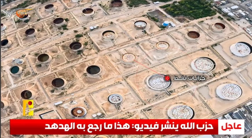
8:13 – Chemical storage tanks.
8:36 – “Iron Dome” stores; Haifa airport [left to right].
8:57 – “Iron Dome” platforms.
9:13 – Oil reservoirs.
9:25 – “And the birds as they soar.” (Al-Nour;41) –